The following was presented to the Clay County Supervisors on July 30, 2019:
The intent of the original petition was to simply address the county tile mains, and this still should be the primary focus. The engineers’ plans that were presented went far beyond the intent and desire of the petitioners. For the supervisors to fulfill their obligation there is no requirement they adhere to the only options presented by the contracted engineering firm.
The intent of this presentation is to convey what the landowners of DD #37 propose as solutions to the biggest issues with the proposed work on the ditch, with the hope of bridging the gap that has caused such angst.
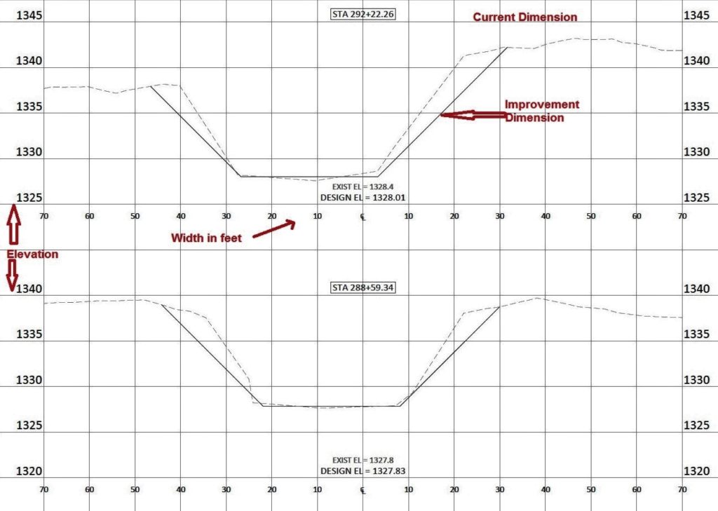
To begin, focus on the section of DD#37 around station 288, between the 310th Ave bridge and the 320th St bridge about a mile from Trumbull Lake. Image 1 above is a cross section of 288, and also 292 which is just a little upstream. The dashed line represents the current dimensions measured by Bolton & Menk; the solid line is the proposed dimension for the improvement. The elevation of the bottom of the ditch is right at design elevation, as is the majority of the ditch, and has not silted in.
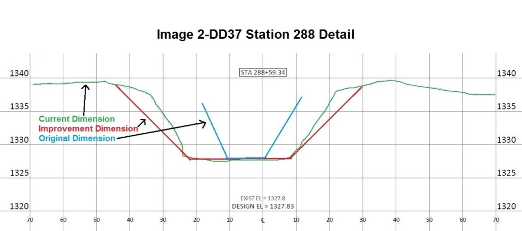
Image 2
Image 2 above is focused on station 288. The current dimensions are highlighted in green; the proposed improvement dimensions are highlighted in red; and the approximate original 12 foot dimensions are overlaid in blue. What becomes immediately obvious is that Pickerel Run has increased in size significantly, all by itself in the last 100 years. Within a decade or so it will surpass the proposed improvement dimensions by letting nature take its course.
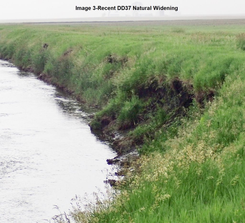
Image 3
Image 3 is a photo taken after the survey was performed and shows obvious additional widening that has occurred. Iowa code 468.126a authorizes trustees to perform work to maintain original capacity or efficiency. Looking back at image 2 it is evident that the current dimensions are transporting far more water than the original design. The Board is under no mandate to perform the massive repairs proposed by Bolton & Menk and must use their fiduciary responsibility to find more cost effective measures of managing the district.
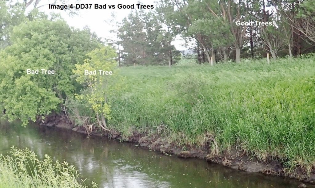
Image 4
What does need to be done? Focus now on image 4 which is near station 288. The good trees and bad trees have been highlighted. When the stream is in flood stage the bad trees are in the water and restrict flow to some degree. These trees should be removed; the good trees have zero impact on flow or tile lines, and are a best use practice for the old spoil bank.
During formulation of the current plan, landowners were not consulted for their input on how best to proceed. While there was awareness that trees were growing up that could be problematic, research into this whole project has made it evident that trees in the floodwaters should be removed. This could just be left to some nameless contractor to do at the expense of the drainage district, but some landowners may prefer the option of taking care of the trees themselves. As an example, the thirty or so trees impacting flow on a particular 1 1/4 miles of stream bank could be removed in about two days. At that point there is absolutely no need for repair on any of that land as the ditch will be functioning significantly beyond original design.
Of the approximately 6 ½ miles of DD 37, the first 2 ½ miles—nearly 40%–is in as good of shape as section 288 or better.
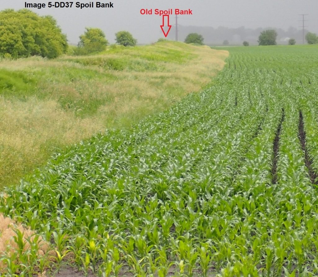
Image 5
Next, let’s address the old spoil banks. Image 5 shows an example of what the spoil banks look like. One of the main reasons given in the Bolton & Menk Report to level the spoil banks is to allow easier access to the ditch for tree removal and future weed control. For the first 40% of the ditch, removing problem trees with the current spoil banks untouched is not a problem. Looking to the future for chemical treatment of volunteer trees, while it might be a bit easier for someone to drive a vehicle along the bank and spray volunteer trees, it would be possible to contract the work using an all-terrain vehicle and a backpack sprayer. The cost of leveling the spoil banks could never be regained in savings for weed control down the line.
In addition, the spoil banks function as levees, which most likely could not be constructed today. If these are leveled, when the creek floods it will allow water to pour over the banks, which would then only be able to return to the stream via the tile lines. This would result in a much longer period of time when fields would be inundated.
Some fields along the ditch that have had the spoil banks spread in the past and are farmed, routinely yield at least 30% less than adjacent land, basically making them unprofitable to farm. No analysis has been done adding in this loss of value in the justifications for the current proposals.
Another justification for the current proposals was that the current banks are too steep, and that they should be more gradual. Images 6, 7, 8, 9, 10, and 11 below show a recently graded drainage ditch in nearby DD #61. While the gentle grade was originally formed, natural processes are quickly returning the bank angle to basically where it is now on DD #37. It would be wasteful to expend resources distributing poor quality soils over good soils in an attempt to have a gentle bank angle when natural processes will, in short order, restore the bank angle to where it now is.
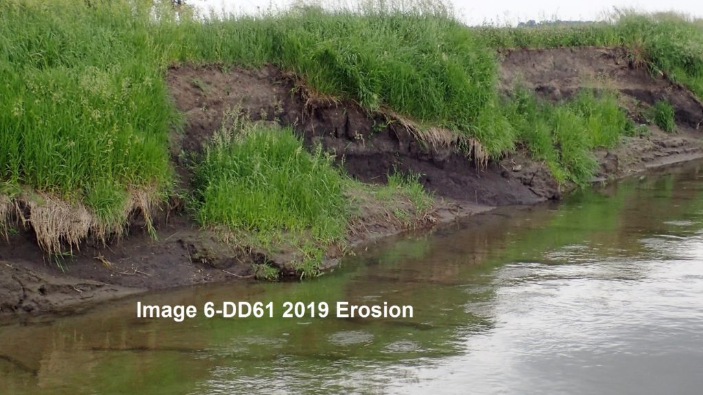
Image 6
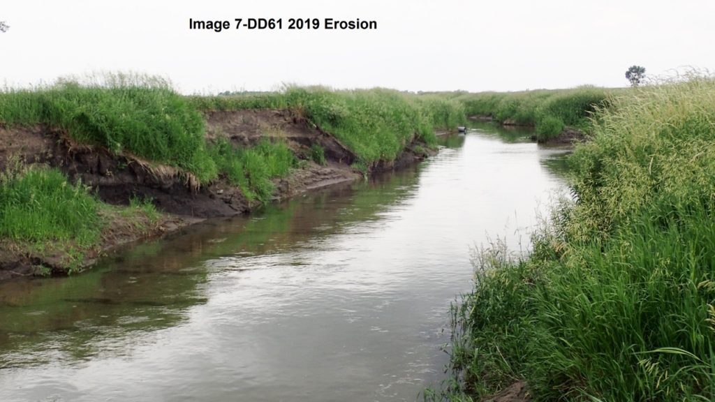
Image 7
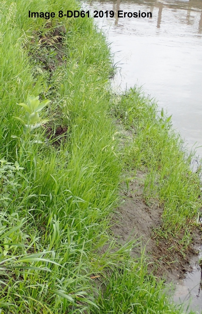
Image 8
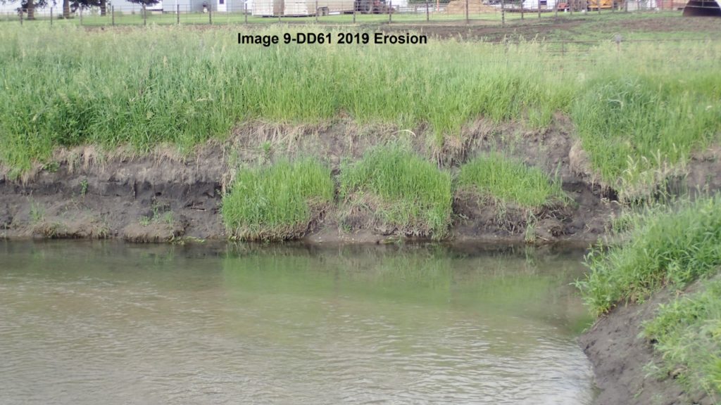
Image 9
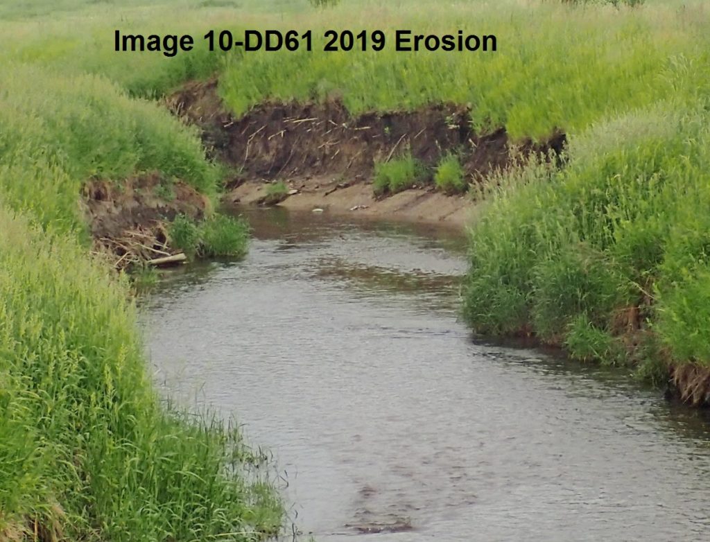
Image 10
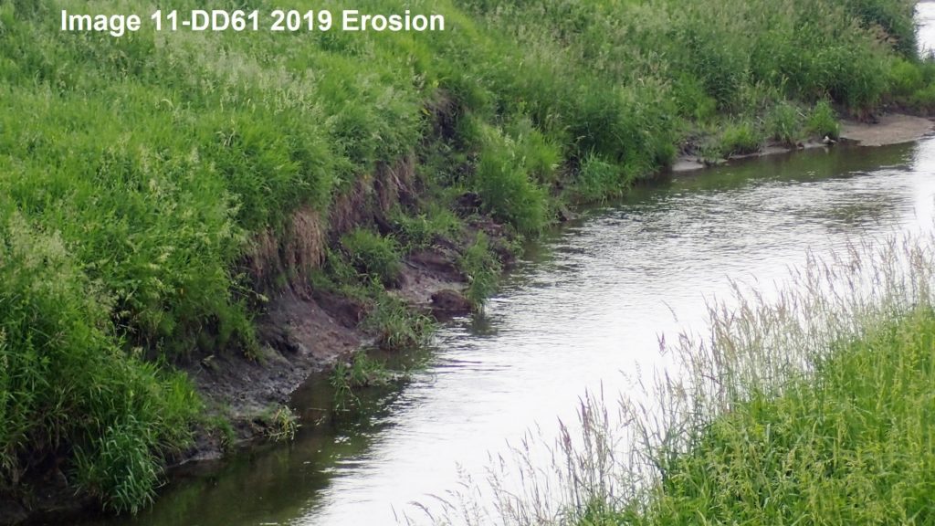
Image 11
Doing anything beyond removing problem trees in the first 40% is wasteful. “What about the rest of the ditch?” you may be wondering.
The first half mile downstream from 300th Ave does have thick trees on both banks, as does most of the first 1.6 miles north of 340th Street. This approximately 30% of the drainage ditch will need more aggressive measures to ensure free flow. The final 30% ranges from similar to the upper 40% to having slightly more trees but could most likely be addressed with minimally invasive measures.
What should be done on these two segments? A very logical step early in this process would have been for the engineering firm to include the landowners of each particular section, and work out the most cost effective solution, but this never happened. Additional steps would be talking with landowners and working with them to come up with solutions. Some might want the banks razed of vegetation and levelled by a contractor; some might want to remove problem trees on their own for fire wood; or some intermediary solution could be reached to ensure free flowing water at minimum expense. Perhaps one bank could be more aggressively addressed allowing access to trees on the other side, thus minimizing the expense.
In regard to annexation, the fact that Trumbull Lake is a reservoir makes it uncertain what contribution annexation would make to the improvement project. It is likely the current landowners of DD #37 would end up footing essentially the entire bill for the improvement if it were to go forward. An alternative would be to do a responsible repair, with the possibility of imposing an outlet fee on the upstream drainage districts that flow through Trumbull Lake.
From the onset of this project, numerous errors have been made. From the remonstrance to the cross section survey, errors are abundant, which does not do much for our confidence in the engineers or any of the proposed projects.
Lawsuits have been filed and much additional expense has been incurred because no effort was made to actually figure out a responsible solution that is mutually satisfactory. We are still in the middle of litigation but a simpler, more cost effective solution could be reached.
The Iowa code calls for little or no repair if a drainage area is functioning beyond original capacity. However, some small strategic investments in tree removal could yield increases in flow capacity for very little cost. Simply addressing county tile outlets satisfies the original petition. Left to its own DD 37 already surpasses its original design and will soon surpass the proposed improvement dimensions all on its own.
A consideration, perhaps, should be how wide the drainage ditch will be allowed to become? Left to its own hydraulics, future generations will encounter a drainage ditch that has consumed much of their fields. Instead of accelerating the erosion process by disturbing the banks, we should be planning at what point we want to stop the banks from expanding. Some sections on the curves are rapidly working out into the fields where rip-rap should be placed and perhaps eventually all the banks could be stabilized, although not until they have reached a point that provides the desired flow.
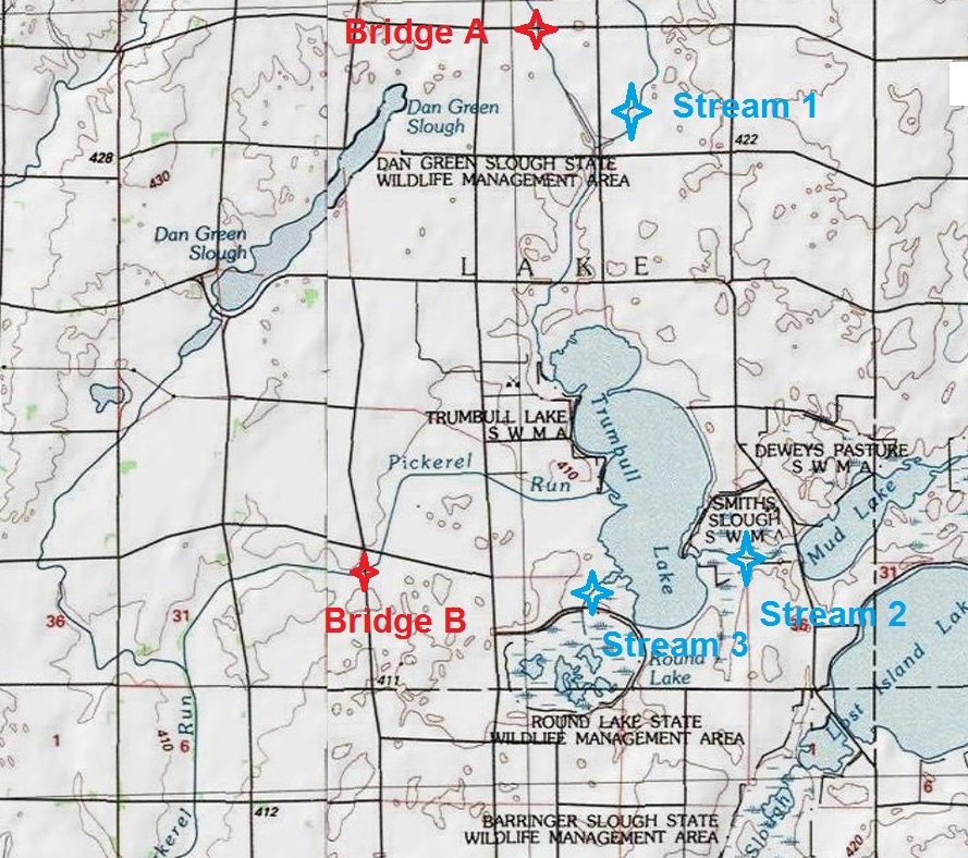
As supervisors, you can direct the engineers to work with the landowners. Remove the problem trees but do it in a manner that is cost effective and addresses the concerns of the landowners. Eliminate trees over county mains and replace them with solid tile when repairs are needed. The bridges on DD #37 also should be addressed to meet future needs. Image 12 above shows that Bridge A upstream from Trumbull Lake is basically the same size as Bridge B on DD #37. Between Bridge A and Bridge B three major streams, plus countless tile lines, add water to the system; more capacity for DD #37 bridges would be a good thing. Working together on all these issues, a plan can be made that will save much money and allow DD #37 to continue to expand in capacity into the future all on its own carrying our water uninhibited beyond our drainage district.
What cost savings would the district be looking at by revising the plans? Starting from the 3.6 million dollar improvement price tag, first off would be the $666,000 improvement construction subtotal which would not be needed. Wetland or channel mitigation would not be needed saving an additional $423,100. Of the repair part of the cost, removing spoil levelling ($184,334) and the surface drains ($139,752) which would then not be needed would save $324,086. What is left of the repair cost could most probably be reduced by 70% by working with landowners, bringing the remaining current proposed budget of $1,542,000 down to around $463,000. At this price point the water flows freely, and the channel will keep getting bigger all on its own. A few thousand dollars per year in weed control and the only thing we need to worry about is how big we will let it become.
When the markets are tough and the weather is challenging, the simple things in life make it worth living. This spring a family was fishing for walleye, catfish, and northerns near the bridge. A flock of goslings was swimming downstream. Nearly every pass across the field yielded sightings of another small group of wood ducks or mallards working along the channel. Pheasants cackled from the CRP along the north bank and song birds flitted among the trees in the field windbreak on the south bank. While there were no deer in sight that afternoon, they are common visitors. A neighbor traps the creek for mink, muskrat, raccoon, and coyote and each fall hunters log hundreds of days, including a myriad of waterfowl hunters to whom we grant free access to our land. Near the end of the day of planting, a bald eagle landed on the top of the big cottonwood high above the creek, lingering for half an hour, watching the planter and doing whatever else it is that eagles do when resting in a beautiful place.
If the plan goes forward as proposed, most of this will be lost, very little or nothing will be gained, and lots of money will be spent. Please work with us.